


Despite a proven wealth of natural resources and a large, albeit suppressed, domestic market, Western interest in Myanmar has so far been limited. Asia, however, is taking far more notice. While immediate neighbors China and Thailand look to promote their own regional priorities in Myanmar, East Asian nations, such as Japan and South Korea, have been offering aid or low-cost loans to give their own companies access to large-scale infrastructure projects.
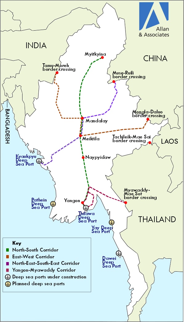
Myanmar’s civilian government has prioritized higher levels of foreign investment and businesses. In February 2016, it published its industrial policy master plan, outlining the establishment of four economic corridors intended to tie the country to the global market through a network of roads, railways, waterways, and airports. The plan’s overarching intention is to position Myanmar as a logistics hub, offering South and Southeast Asian countries overland routes into Bangladesh, China, India, and Thailand.
As of now, such plans are at best aspirational. Decades of underinvestment in infrastructure and poor maintenance of existing highway networks mean that many secondary roads, particularly in the coastal regions, remain little more than single-lane, unpaved tracks. According to the Asian Development Bank, the average road density in Myanmar is 2 km per 1,000 people, a much lower rate than the ASEAN average of 11 km per 1,000 people. Only one expressway, the 590 km Yangon-Mandalay highway, which is part of the Asian Highway 1, boasts four concrete surface lanes.
To upgrade its weak national road network, the government has declared plans to build around 34,400 km of roads over the next 20 years with foreign aid and other loans. Most of the work will center on the economic heartlands of Yangon, Mandalay, Bagan, and Pyay, regions dominated by the majority ethnic Bamar population. However, there are many factors that can, and probably will, prevent such an ambitious program being fully realized.
Route Problems
While four new economic corridors are detailed in the plan, the North-South highway is by far the most ambitious and strategically important. It will link Yangon’s proposed Thilawa Deep Sea Port in the south, through Bago, the capital Naypyidaw, Mandalay, and Sagaing, ending in Myitkyina, in the northern Kachin State. More than half of the country’s economic activity will be located along this highway.
Two of the routes will be connected to the Thilawa and Kyaukpyu Special Economic Zones (SEZs) located in the south and west of the country, respectively. The former is a joint venture between the Japan International Cooperation Agency and the government, while the latter is being developed by China’s CITIC Group Corporation.
Notably missing is any mention of the Dawei SEZ in Tanintharyi Region, which was promoted as the largest in Southeast Asia, to join the Thai capital of Bangkok to Myanmar. Since the project was awarded to Thailand-based Italian-Thai Development PCL in 2008, progress has been delayed by a host of problems, ranging from funding issues to accusations of human rights violations. The elimination of the SEZ in the government’s master plan likely reflects such complications.
The plan also reflects Myanmar’s existing patterns of cross-border trade. China is the country’s main trading partner, and there are three proposed routes intended to link the landlocked Chinese province of Yunnan to ports in the Bay of Bengal and the Andaman Sea, as well as with India and Thailand. While trade with Myanmar’s eastern neighbors, China, Thailand, and to a lesser extent Laos, will certainly grow strongly in the next five years, the same cannot be said for its western neighbors. So far, there is no intention to further extend overland connections with Bangladesh, while land routes to India remain confined to the Tamu (Myanmar)-Moreh (India) link. Complex and troubled historical and political relations mean that transport ties across these borders are unlikely to improve in the five-year outlook, limiting Myanmar from realizing its self-proclaimed intention of becoming a regional transport hub.
Risks Without Rewards?
Domestic problems are also set to hamper, delay, and prevent construction of new roads. A key challenge for planners and engineers are long-standing grievances over land ownership and related re-settlement issues. Land disputes will likely become more prominent, contested, and violent as Myanmar starts to industrialize. This will add significant risks for foreign investors and contractors due to legal complications relating to contested land ownership, financial penalties for delays, and reputational damage relating to the suppression or dispossession of communities.
The absence of any clear system of land management or comprehensive land legislation will make route planning and construction a complex and fraught undertaking. Some challenges will include dealing with more than 20 government agencies in the legal and administrative processing of claims and untangling the numerous overlapping provisions within the existing legislation. Moreover, the plight of displaced communities, often poorly compensated and resettled in areas with little or no access to arable land or basic resources, could appear in the international media and potentially compromise the international reputation of foreign contractors working on the projects.
Even if the roads are built, the movement of goods across the region’s borders could be a time-consuming process. Existing major border crossings such as Myawaddy (Myanmar)-Mae Sot (Thailand) and Muse (Myanmar)-Ruili (China) suffer from high levels of corruption and smuggling. In 2014, Myanmar’s Ministry of Commerce estimated the country was annually losing $1 billion in customs duty at the Myawaddy-Mae Sot border post alone.
This partly reflects the activities of ethnic non-state armed groups (NSAGs) that operate with impunity in many of Myanmar’s border regions. These groups draw much of their revenue from the trafficking of illegal goods, including drugs, jade, timber, and wildlife. They also operate illegal checkpoints along key roads to collect “tolls” from the steady stream of trucks passing through their territory. In 2016, for example, a faction of the Democratic Karen Benevolent Army NSAG established as many as nine toll collection points along the Asian Highway 1 that connects Thailand to Myanmar and on to India.
Many of the NSAGs’ actions are implicitly authorized by the powerful military, who themselves extort and demand bribes from passing traffic. With more than a dozen NSAGs along the Chinese border, about half a dozen along the Thai border, and a handful along the Indian border, they pose significant threats to freight and personnel, which will continue until a peace agreement is reached between them and the state, particularly with the army.
While some projects, notably those that suit China’s interests, might go ahead and improve basic infrastructure, expansion of the country’s road and rail map will prove to be challenging over the coming 20 years. Great river valleys flowing from north to south and extensive mountain ranges have historically made rapid east-west communications extremely costly. To overcome such formidable natural obstacles would involve a concerted effort to channel large sums of money into infrastructure development, which is much higher than the current level of foreign direct investment.
Jieyi See is an Asia-Pacific political risk analyst with Allan & Associates, a security risk management company.