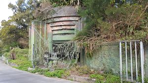
Fortifications on Matsu Island were meant to defend against a communist invasion.
By Guy Plopsky
February 22, 2017
An abandoned camouflaged fortified gun emplacement on Beigan Island facing the Taiwan Strait. Such emplacements are a common sight on Matsu.
Credit: Guy Plopsky
Protruding from the hillside, the entrance and machine gun ports constitute part of Stronghold No. 6, which once guarded Beigan’s airport and administrative center. Renovated by the Taiwan Tourism Bureau in 2006, the stronghold is now part of Matsu’s War and Peace Memorial Park and is open to visitors.
Credit: Guy Plopsky
The secondary gun emplacement of Stronghold No. 6. According to the Matsu National Scenic Area Administration, this World War II era 57mm M1 anti-tank gun was one of 400 such artillery pieces acquired by the Republic of China (ROC) military from the United States in 1950. Many of the M1 guns on Matsu were adapted for coastal defense.
Credit: Guy Plopsky
A M108 105mm self-propelled howitzer near Stronghold No. 8 in Beigan’s War and Peace Memorial Park. Taiwan’s military acquired a small number of M108s from the United States in the 1970s. They have since been superseded by the more capable 155mm M109 self-propelled howitzer.
Credit: Guy Plopsky
The view of the Beigan airport from Stronghold No. 12. The stronghold is now the site of the War and Peace Memorial Park’s exhibition center. Beigan Township occupies an area of 9.9 square kilometers (3.8 square miles) and is home to just under 2,350 residents.
Credit: Guy Plopsky
The interior of Nangan Island’s infamous Beihai (North Sea) Tunnel. This colossal network of underground canals, which runs deep into the mountain, is 640 meters (2,100 feet) long, 10 meters (33 feet) wide and 18 meters (26 feet) tall, and is large enough to house over 100 small landing craft. Nearby hills concealed the network’s entrance and exit from communist eyes.
Credit: Guy Plopsky
Beihai Tunnel on Nangan Island was built as part of the ROC military’s 1968 “Beihai Project,” which included the construction of two other large underground canal networks on Beigan and Dongyin islands. The Matsu National Scenic Area Administration notes that the Nangan network – the largest of the Beihai tunnels – was constructed over a period of 820 days with soldiers using only explosives and basic tools to carve through the granite. Countless men lost their lives building these tunnels.
Credit: Guy Plopsky
Completed in 1976 using only explosives and basic tools, Nangan’s Dahan Stronghold constitutes a complex three-level fortification with a 430 meter (1410 feet) long tunnel network that was dug into the hill opposite the entrance to the Beihai Tunnel on the Teiban Coast. The lower level of the stronghold housed, among other things, four 90mm anti-aircraft guns adapted for coastal defense. Following renovation by the Matsu Scenic Area Administration, the stronghold was opened to visitors in 2006.
Credit: Guy Plopsky
Built into a single coral rock near Renai Village in southwest Nangan, the Tiebao (Iron Fort) once housed elite Taiwanese frogmen units and various facilities to sustain them. In order to deter surprise night attacks by Communist frogmen, iron rods and glass shards were embedded into the rocks around the fort – they are still clearly visible to this day.
Credit: Guy Plopsky
The view on Renai Village from a guard post on Iron Fort. Renai Village is one of several small villages on Nangan Island, Nangan Township.The largest and most populous of Matsu’s townships, Nangan Township covers an area of 10.4 square kilometers (4 square miles) and has a population of just under 7,400.
Credit: Guy Plopsky
Located near Nangan airport, Tunnel 88 is was completed in 1974 and is 273 meters (896 feet) long. The number 88 is a reference to Chiang Kai-shek’s 88th birthday (Chiang died in 1975 at the age of 87). The tunnel is large enough to hold an infantry brigade. In 1992, the Matsu winery was granted ownership of the tunnel and it has been used for alcohol storage since.
Credit: Guy Plopsky
Old wine jugs stored in Tunnel 88. A smaller, secondary tunnel is used to house storage tanks with locally produced Kaoliang spirits. According to the Matsu National Scenic Area Administration, the tunnel’s year-round stable temperature makes it very suitable for storing alcohol.
Credit: Guy Plopsky
An abandoned World War II era M24 Chaffee light tank on Dongju overlooking Xiju Island. Both Dongju and Xiju are part of Juguang Township. The township is just 4.7 square kilometers (1.8 square miles) in size and is home to just over 1,500 residents.
Credit: Guy Plopsky
A deserted Taiwanese military facility on the northwestern coast of Dongju Island.
Credit: Guy Plopsky
A view of the cliffs of Dongju Island’s northeastern coast as seen from an abandoned ROC army camp.
Credit: Guy Plopsky
One of two M115 8 inch howitzer emplacements on Dongju’s northeastern coast. The Dongquan Lighthouse seen in the background was built by the British in 1872 and was used to assist ships in navigating to Fuzhou (one of the five treaty ports the Qing Dynasty was forced to open following its defeat in the First Opium War in 1842).
Credit: Guy Plopsky
Located just several miles off the coast of mainland China, the tiny Matsu Islands — along with the larger Kinmen group of islands — were destined to become major Nationalist strongholds following the Kuomintang’s (KMT’s) retreat to Taiwan in 1949.
Throughout the Cold War the Nationalists constructed elaborate tunnel networks and large numbers of various fortifications on Matsu. Their purpose was to aid in defending against a potential communist invasion and to house large quantities of troops, equipment, and supplies as part of Chiang Kai-shek’s plan to retake mainland China. To this day, the exact number of military installments remains a closely guarded secret.
The Lienchiang County government (which administers Matsu’s 36 islands and islets) estimates that — excluding facilities still in use by Taiwan’s military — some 256 underground fortifications, tunnels, air raid shelters, and other related structures were constructed in Matsu’s four townships: Nangan, Beigan, Juguang, and Dongyin.
The numerous military fortifications found on the islands once provided overlapping firing arcs both in the direction of mainland China and in the direction of neighboring islands within the Matsu Islands group. Many of these fortifications housed various artillery pieces, including anti-tank and anti-aircraft guns that were adapted for coastal defense. The islands also feature large numbers of abandoned World War II and early Cold War era U.S.-built armored vehicles that were once utilized by Nationalist forces.
Today, the renovated fortifications and tunnels bring Matsu’s tense Cold War past to the attention of visitors and serve as monuments to the countless men who lost their lives constructing them, often with little more than the most basic of tools. At the same time, the ongoing (albeit smaller) military presence on the islands — often concealed by Matsu’s tranquility and captivating natural beauty — serves as a reminder that, despite the warming of relations following the end of the Cold War, tensions on the Taiwan Strait remain high.
Guy Plopsky holds an MA in International Affairs and Strategic Studies from Tamkang University, Taiwan. He specializes in air power, Russian military affairs and Asia-Pacific security. You can follow him on Twitter.