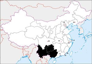
This article series explores 12 distinct “regions” within China: six “core” regions long dominated by the majority Han ethnic group and six “periphery” regions home to many of China’s ethnic minorities. The series overview is available here. To view the full series, click here.
From the mountain-split river valleys of Guangxi, the land rises westward through Guizhou and Yunnan into the southeast corner of the Tibetan plateau. Here the upper reaches of the Salween, Mekong, and Yangtze rivers run between the parallel ranges of the Hengduan mountains, which funnel the monsoon rains to nourish one of the world’s biodiversity hotspots. Further east are the karst landscapes familiar from Chinese watercolors and tourism commercials. Yunnan is likely the original site of tea cultivation, and the region was crossed by ancient tea caravan routes comparable to the Silk Roads.
This area is home to most of China’s 55 ethnic minorities, pushed southwards and upwards (into hilly and marginal lands) by the millennia-long expansion of Han settlement. Many of these peoples practice wet rice cultivation, and they have built some of the world’s most spectacular terraced landscapes. Some groups migrated into highland Southeast Asia, including Vietnam, Laos, Thailand, and Myanmar, where they maintain armed self-determination movements. More so than in Inner Mongolia, Xinjiang, or Tibet, the minorities of this region have absorbed Han cultural influences over the centuries, facilitated by physical proximity and a similar mode of agricultural life.
Chinese control in the mountainous Southwest expanded slowly through state-led colonization and military operations, often portrayed as punitive expeditions against rebellious natives. A regular Chinese administrative structure based in garrison towns coexisted with rule through aboriginal chiefs (土司) in the countryside. Han in-migration accelerated from the 1200s under rule by the Mongols, who extinguished the independent state of Nanzhao-Dali in Yunnan and brought it into the empire. Further Chinese southward expansion was checked by the kingdoms of Vietnam and Burma, which vied with China for the loyalty of chiefs and princes along the frontier.
Recurring minority uprisings across this region had to be violently suppressed up to the late 19th century. In 1934-35 the Red Army passed through the southwest on the Long March, making pledges of recognition and autonomy to the peoples it encountered en route; this experience helped shape the People’s Republic’s ethnic minority policy. While the region has not seen major unrest since 1949, its landlocked and rugged terrain has perpetuated grinding poverty; Yunnan and Guizhou are China’s second and third poorest provinces per capita. Guizhou in particular is said to have “not three miles of flat land, nor a person with three pieces of silver.”
Yunnan’s planned path to riches is through integration with the Greater Mekong Subregion and possibly with South Asia, facilitated by Chinese-built road and high speed rail links. Unsurprisingly the province is exhibiting the typical ills of construction-led growth, while the building of hydroelectric dams on the Mekong and Salween has dire implications for downstream countries. Guizhou is also taking the development path of devil-may-care infrastructure spending, with the province’s debt-to-GDP ratio now leading the nation at almost 90 percent; recently completed projects include the world’s highest bridge and biggest radio telescope. The provincial capital Guiyang is emerging as an international big data hub, leveraging its topography and climate to provide cheap hydroelectricity and natural cooling for mass server facilities.
Next up: The implications of China’s 12 regions.
John Lee is a former visiting fellow of the Mercator Institute for China Studies. He tweets at @J_B_C16.


