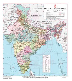
After sparking a regional and worldwide controversy by changing the internal status of Kashmir, India’s new official political map is stirring criticism in Nepal, including from Nepal’s Ministry of Foreign Affairs (MOFA). The updated map of India released on November 2 includes a major Nepali claim, an area known as Kalapani. Four days after the map’s release, Nepal’s MOFA released a press statement objecting to the inclusion of Kalapani in the Indian map.
The press statement stated: “The Nepal government firmly believes that the Kalapani is a part of Nepal.” India’s unilateral and illegal move to encroach upon Nepal’s Kalapani goes against the 1816 Suguali treaty between Nepal and the then East India Company.
Kalapani is a 35 square kilometer area in the hill state’s Pithoragarh district under the control of the Indo-Tibetan Border Police. The Indian state of Uttarakhand shares an 80.5-km long porous border with Nepal and a 344 km border with China.
The Kali River originates from Kalapani and, surprisingly, India now has included the river in its map when it had removed its existence previously. According to the 1816 Sugauli treaty (Article 5) signed between the East India Company and Nepal, the Kali River was treated as the western border between the East India Company and Nepal. After the 1962 war against China, India’s troops entered Kalapani illegally and stationed troops there, without Nepal’s permission. In 1961, prior to the India-China war, according to Nepali land surveyors, Nepal had done a population survey in Kalapani and India had no say in it then.
But this trend of including Nepal’s territory within India’s borders is not a new thing. The Survey of India, the national mapping authority, has been including Nepal’s Kalapani and Navidhang area since 1905, completely disregarding Nepal’s territorial sovereignty. For example, the aforementioned department included the lands of Nepal in their maps of 1850, 1856, 1879, 1905, and the recently published one. The interesting part is that in India’s 1856 map, the origin of Mahakali is shown at Lipudhara. The British Indian government had accepted these maps, which are now securely kept at London’s India Office Records.
Despite Kathmandu having historical claims and proof in its favor, the Indian government has continuously ignored Nepal’s claims. It is not just Kalapani that India has encroached upon. According to Buddhi Narayan Shrestha, in his book Border Management of Nepal, the “Indian Armed military-men of the Indian Military Check-posts, deputed on 9 June 1952 in the northern frontier of Nepal, were put away and sent back to India by the Government of Nepal on 20 April 1969” (page 259). According to a report by the Associated Press, the Indian troops had withdrawn in December 1969.
Furthermore, the Nepal-China March 20, 1960, treaty also supports the claim of Nepal (per Article 1):
The Nepalese-Chinese boundary line starts from the point where the watershed between the Kali River and the Tinkar River meets the watershed between the tributaries of the Karnali (Mapchu) River on the one hand and the TInkar River on the other hand, thence it runs southeastwards along the watershed between the tributaries of the Karnali (Mapchu) River on the one hand the TInkar River and the Seti River on the other hand, passing through Lipudhura (Niumachisa) snowy mountain ridge and Lipudhura (Tinkarlipu) Pass to Urai (Phelin) Pass.
Interestingly, there’s no Sino-Nepali border in the area now, since India has openly occupied Kalapani — exposing itself to the Chinese threat. India continues to make error after error, including the 2015 economic blockade, against Nepal. This move too will worsen relations between Nepal and India.
Ashok Swain, professor with the Department of Peace and Conflict Research at Uppsala University, says, “India has not many friends left in its neighborhood. Particularly, its relationship with Nepal has deteriorated considerably since unofficial blockade in 2015 while China is doing everything to get Nepal to its side.”
“In this critically sensitive time of bilateral relationship, India’s ham-handed decision to put Kalapani as part of its territory in its new map is nothing but self-defeating. If anything, it is only going to serve China’s interest,” he adds.
But the issue of border encroachments is not unique to India; China is equally blamed for it in Kathmandu. Lipu Lekh pass, another integral part of Nepal close to Kalapani, has been made a trading tri-junction route between India and China without Nepal’s consent since 2015, making Nepali counterparts suspicious of China’s intentions too.
The examples of Kalapani and Lipu Lekh raise questions as to whether a landlocked and small nation is helpless when two bigger nations encroach on its lands.
Bipin Adhikari, a constitutional expert, told The Diplomat, “Who says Kalapani, Lipu Lekh, and Limphuyadhara are ‘disputed territories’? They are part of Nepal and will remain so. The Indian security forces must go back the way they moved in during the Sino-Indian war. Enough is enough! The age of occupation must come to an end.”
Maoist rebels in the past have been critical of the Suguali treaty and had asked for its abrogation, but since coming to the government as the Nepal Communist Party (NCP), the party seems to have taken a diplomatic approach to the issue.
Above all, India’s expansionist move would appear to invalidate the 1950 Treaty of Peace and Friendship, which asks for a mutual commitment on security, and also makes a laughing stock of the so-called “Special Friendship” that India likes to refer to when talking about the Nepal-India relationship. The continuous disregard of Nepal’s territorial sovereignty by India will only play a major role in pushing Nepal away, alienating one of its closest friends.
Nepal’s foreign minister, Pradeep Gyawali, expressed the government’s reservations against India’s occupation of Kalapani. India also made a statement saying there was no boundary dispute with Nepal, ignoring historical facts and proof.


