Photo Essays

Glimpses of Kaho: A Village Along the Line of Actual Control on the India-China Border

Recent Features

Photo Essays | Politics | Security | South Asia

Glimpses of Kaho: A Village Along the Line of Actual Control on the India-China Border

Kaho is a village on the easternmost tip of India.

Glimpses of Kaho: A Village Along the Line of Actual Control on the India-China Border

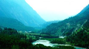
A spot in Kibithoo block of Arunachal Pradesh on the road between Wallong and Kaho.

Credit: Rajeev Bhattacharyya
Glimpses of Kaho: A Village Along the Line of Actual Control on the India-China Border

Kaho Village, which is less than a kilometer from the Line of Actual Control between India and China.

Credit: Rajeev Bhattacharyya
Glimpses of Kaho: A Village Along the Line of Actual Control on the India-China Border

The Line of Actual Control (LAC), at third hill on the right, as seen from Kaho.

Credit: Rajeev Bhattacharyya
Glimpses of Kaho: A Village Along the Line of Actual Control on the India-China Border

Children in Kaho watch videos on a smartphone.

Credit: Rajeev Bhattacharyya
Glimpses of Kaho: A Village Along the Line of Actual Control on the India-China Border

Primary School in Kaho.

Credit: Rajeev Bhattacharyya
Glimpses of Kaho: A Village Along the Line of Actual Control on the India-China Border

A foot suspension bridge over Lohit river connects Kaho with Kibithoo.

Credit: Rajeev Bhattacharyya
Glimpses of Kaho: A Village Along the Line of Actual Control on the India-China Border

Water supply is continuous in Kaho and is sourced from the perennial rivulets around the settlement.

Credit: Rajeev Bhattacharyya
Glimpses of Kaho: A Village Along the Line of Actual Control on the India-China Border

A shop in Kaho which sells essential commodities and a wide range of items from soaps to food stuff.

Credit: Rajeev Bhattacharyya
Glimpses of Kaho: A Village Along the Line of Actual Control on the India-China Border

Rice cultivation in the fringe areas of Kaho.

Credit: Rajeev Bhattacharyya
Glimpses of Kaho: A Village Along the Line of Actual Control on the India-China Border

Construction of a new health center.

Credit: Rajeev Bhattacharyya
Glimpses of Kaho: A Village Along the Line of Actual Control on the India-China Border

Firewood gathered from the neighbouring hills is the primary fuel for cooking at Kaho.

Credit: Rajeev Bhattacharyya
Glimpses of Kaho: A Village Along the Line of Actual Control on the India-China Border

A Buddhist Monastery at the outskirts of Kaho.

Credit: Rajeev Bhattacharyya

Located on the easternmost tip of India along the Line of Actual Control (LAC) with China is Kaho, which happens to be among the few villages on the border to be linked by a road.

Kaho is one of the seven villages of the Kibithoo block in Arunachal Pradesh’s Anjaw district through which the river Lohit flows and divides the scenic region into the west and east banks. They are connected at several places by foot suspension and bailey bridges.

Kaho is inhabited by the Meyor community who are Buddhists by faith. According to the 2011 census, it has a total population of 65 residents and a literacy rate of 64.15 percent, which was lower than the 65.38 percent level for the entire state of Arunachal Pradesh.

Last year, when this correspondent visited the village, residents claimed that the population of the village had increased to over a hundred with more households being established as well.

However, similar to the situation during the earlier period, residents continue to suffer from a lack of basic amenities. The village’s health center remains shut and children have to attend the high school in Kibithoo, located around 5 kilometres away on the north bank of the Lohit river.

Without either access to landlines or cellular phone connections, the villagers often depend on the army to speak to their relatives in Wallong and other places.

Despite these handicaps, Kaho is among the very few villages along the LAC in Aruanchal Pradesh that is connected by a road. Several projects are on currently to broaden the highway from the district headquarters of Hawai to facilitate the construction of bridges over the river.

China claims 90,000 square kilometers of India’s Northeast, which includes the entire border state of Arunachal Pradesh. The region around Kaho had witnessed ferocious action during the India-China war in 1962. when it briefly came under occupation of the People’s Liberation Army.

The war began on October 21, 1962, when the PLA launched attacks at the Dhola sector on the western fringe of the state and at a post at Kibithoo. India was able to launch a counterattack during the war at the Battle of Walong. when the invading army was held back for close to three weeks along the Kibithoo-Walong line.

Rajeev Bhattacharyya is a senior journalist in Assam, India.

Dreaming of a career in the Asia-Pacific?
Try The Diplomat's jobs board.
Find your Asia-Pacific job