Rivers in India’s Northeast often conjure up images of pristine pure waters. But a river in the border state of Arunachal Pradesh has been found to have the highest turbidity among all rivers in the Ganga-Brahmaputra deltaic system. This could have far-reaching implications for the ecosystem of the region.
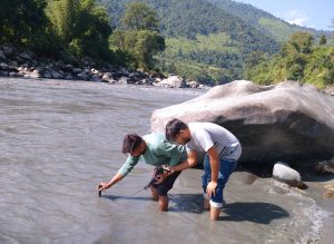
This was the conclusion arrived at by a team of five scientists from the Kolkata-based Indian Institute of Science Education and Research (IISER), who were commissioned by the Arunachal Pradesh government to conduct research on the Kameng river.
The Kameng river flows through two western districts of Arunachal Pradesh before merging with the Brahmaputra in Assam.
The IISER research team has submitted a report to the government identifying the causes. They are in the process of compiling another report that will spell out the measures to be taken to restore the health of the river.
“Currently, turbidity in the Kameng river has decreased to some extent but it is still at a dangerous level. If the current level does not go down, it will lead to long-term changes in aquatic biodiversity of the river, including adverse consequences on the fish population and human livelihood,” said Professor Punyasloke Bhadury, who led the research team from Kolkata.
“Such changes could ultimately become irreversible and will have long lasting impact on Himalayan biodiversity and on many of the rivers in the flood plains of Assam,” he added.
The scientists were tasked to carry out the research when the river turned unusually muddy in October last year.
The government was unable to fathom the causes that triggered the turbidity last year. Officials speculated that a landslide, glacier movement, and erosion on Warriyang Bung river, which is a tributary of Kameng, might have caused a massive amount of mudflow causing the water to turn dark.
A large number of dead fish were found floating on the river in East Kameng. Subsequently, the government issued orders prohibiting anyone from venturing into the river and banned fishing, selling, or consuming fish from the river for two weeks. Samples of fish were collected and sent for food safety testing.
When physical inspection was conducted at various points along Seppa-Chayangtajo, it was found that water in all the tributaries of Kameng, such as Para, Pakke, Pachuk, Pachi, and Pacha, was clear while thick deposits of clay and tree debris were found on the river bank at Marjingla.
Alarmed over the development, the government had also approached the North Eastern Space Application Centre (NESAC) in Meghalaya and Central Water Commission seeking assistance in identifying the causes and the source of the turbidity.
After studying the water samples, the scientists from Kolkata found that the turbidity was due to several factors, including seismic events of low intensity as well as glacier movement and the resulting continuous flow of mud and debris. The scientists are of the view that the impact of anthropogenic climate change across India’s northeastern region should also be considered in understanding the phenomenon, which would require background data for a correlation with glacier movement or melting.
The team found that the mudslide brought in plastic and microplastic, which were littered along the river banks as a result of human activities. They believe that raw sewage and solid waste disposal into the river at a place close to Seppa might have led to a high coliform load in the water.
Bhadury pointed out that microplastic in the river could fuel “cascading effects” on the biodiversity of the region. Therefore, he said, spatial mapping of microplastic load would have to be envisaged as the river passes through biodiversity-rich regions in the downstream areas such as the Pakke Wildlife Sanctuary.
He hinted that identification of the source of plastic pollutants coupled with long-term control along the course of the river, release of fishlings into the river, citizen-driven initiatives to monitor the long-term health of the river, and development of a warning system for rapid deployment of disaster management teams would be mentioned in the final report.


