


")


At midnight on March 1, a message popped up on my mobile phone: “Another house just collapsed in front of my eyes.” The message was from a friend who works with the Helping Hand Foundation, a non-government organization in Gwadar. Other messages and calls from family and friends that followed had me worried.
A 30-hour-long heavy downpour that resulted in flash floods in Pakistan’s southwestern coastal district of Gwadar in Balochistan province caused widespread damage. The administration declared a state of emergency in the district to facilitate rescue and relief efforts. But even after several days, relief supplies are yet to reach many people.
Thousands of people have been affected by the floods. Many have been displaced. Hundreds have lost their homes and livestock. Agricultural land is under water. Surrounding villages are submerged and cut off from the main city and highways, making it hard for relief work and rescue teams to reach them.
Photographs of the once bustling Mullah Fazul Chowk show that Gwadar’s renowned town center has turned into a river. The water, which is mixed with sewage, is dark green. Most of the town’s shops and houses are submerged.
Sitting in my cozy room in my current home in the Canadian province of Alberta, far away from my original home in Gwadar, I scroll through the photographs and messages. I am overwhelmed by a strong feeling of guilt, and filled with an urge to be with my loved ones in Gwadar.
This is not the first time that Gwadar has been submerged and a state of emergency declared due to the dire situation. How many times more should it suffer floods before the authorities improve infrastructure in a way that lessens the damage?
Gwadar experienced severe flooding in 2005 and 2010 as well.
It is a different city today. A massive and modern deep-sea port and connectivity infrastructure have been built here as part of the China-Pakistan Economic Corridor (CPEC). Billions of dollars have been invested in infrastructure development in and around the district. Although the region is known to be prone to natural disasters, functional disaster management and early warning systems are still missing,
Gwadar district comprises four major tehsils or subdistricts: Gwadar city, Ormara, Pasni, and Jivani. It has a 600-kilometer-long coastline, a total land area of 12,637 sq km, and a population of around 260,000 people.
UNESCO had long declared the entire coastal belt of Pakistan a high-risk region for coastal disasters, floods, earthquakes, and tsunamis. Yet, from the smallest towns to the largest cities, not one is prepared for even two days of rain. The region’s high rates of multidimensional poverty expose it to even higher risk and loss.
“Gwadar’s extraordinary geography, a low-lying coastal area with a modest elevation above sea level, makes it extremely vulnerable to disasters,” the Gwadar-based researcher and hydrologist Pazeer Ahmed told The Diplomat.
Gwadar city is surrounded by water on three sides. “Sea level rise combined with a rise of underground water levels are increasing dangers. Fazul Chowk and Shaheen Chowk are among many areas in the city that are at a lower elevation. Rainwater collects here as there is no fully functional drainage system in place. As for Faqeer Colony, it is built on a river plain area,” Ahmed pointed out.
“Nature is one factor, but there are faults in urban planning too,” he added.
Gwadar has a difficult relationship with water. It doesn’t rain for several years at a stretch and people have to struggle with droughts and water shortages. Then there are downpours for days, which culminate in flooding. With climate change, these patterns are becoming the new normal.
To protect the cities from flooding, urban planners are increasingly focusing on keeping the excess water out, often turning to gray infrastructure — a network of drainage and water retention infrastructure such as pipes, ditches, culverts, and retention ponds to prevent flooding.
“There was a natural flow of water in earlier days towards the ocean on both sides of the city, which is disturbed now with the construction of roads on either side,” Nasir Rahim Sohrabi, head of a local social development organization told the Diplomat. “The few drains and culverts constructed by the Gwadar Development Authority (GDA) are not sufficient to drain out large amounts of water,” he said.
To the south of Gwadar city, there is the 11-km-long Koh-a-Bateel, a 150-meter-high headland that protects the city from the open ocean. In the east runs the six-lane East-Bay Expressway, and across the western part of the city runs the Marine Drive, a two-way road along the coastal belt.
“Both the East-Bay Expressway and Marine Drive have drainage systems. A lot of the water from the recent rainfall flowed through these drains into the ocean,” Sami Baloch, a civil engineer at the GDA, said.
Yet, the drainage system could not keep the water out of the city. Instead, water collected on roads and residential areas and flowed into houses.
“The major issue here is the city’s geography. Most of the old neighborhoods are located in areas of lower elevation. The new roads — the East-Bay Expressway and the Marine Drive — are at higher elevations and there are drainage systems here. But most of the surrounding neighborhoods are located in areas of lower elevation, are old and unplanned and lack drainage systems,” said Ahmed.
Although the GDA put forward several master plans for the city, none focused much on the residential areas of the city.
“We need more research into the area’s geography and geology. Investing in data collection and combining that with a participatory approach is key,” emphasized Ahmed.
“Data tells you where drainage should be, where and how residential areas should be built, construction codes, and so on. A participatory approach where government, major stakeholders and residents work together leads to better planning but unfortunately is missing here. For any changes in the area, it is also crucial to compensate the residents,” he said.
For now, the water in most of the city is being pumped out by large water tankers.
“In some parts of the city, large trenches are being dug to facilitate drainage,” Sohrabi said, pointing out that “this a quick fix.”
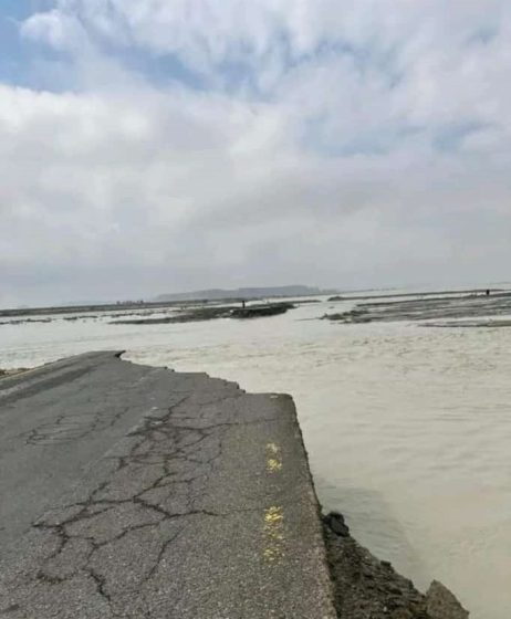
Stretches of the Gwadar-Pishukan Road that have been washed away following heavy rainfall and flash floods, Gwadar, February 29, 2023. Photo by Anayatullah Baloch
So far, all the draining and relief work is focused on Gwadar city. “Many of the villages like Pishukan, where people have lost their houses, livestock and fishing boats, are cut off from major roads and are getting little support,” said Anayatullah Baloch, a resident of Pishukan.
The day after he was sworn in as Pakistan’s new prime minister, Shehbaz Sharif visited Gwadar, where he announced a relief package for the district. He promised to help rebuild the damaged houses and provide for daily distribution of 7,000 ration bags among the displaced people. Sharif said that compensation packages will be delivered within four days to those who have lost homes and kin.
However, people are skeptical. “In 2022, many of our people lost everything. There were government surveys, but none received any support,” complained Anayatullah.
While compensation and relief are the need of the hour, addressing the underlying issues that result in flooding is key. Pakistan ranks eighth among the countries with the highest risk of flash floods and coastal flooding.
The way forward is to identify the areas that are most vulnerable to flooding and opt for more resilient planning. Better disaster management, poverty alleviation and urban development and planning will reduce the impact of heavy rains.
For a district like Gwadar where Pakistan foresees its future through a mega project like CPEC, the country must invest in better urban planning.