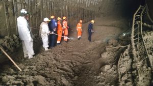
The collapse of a part of a Himalayan glacier in Chamoli district in the northern Indian state of Uttarakhand on February 7 has unleashed a massive disaster in the region. Around 26 people have lost their lives in the deluge so far and another 171, many of them workers in hydropower projects, are missing. Some 35 workers are believed to be trapped in the 2.5 kilometer-long tunnel of the Tapovan hydroelectric project.
The broken glacier hurtled into the Alaknanda river system, setting violent surges of water rushing through the steep Himalayan mountain gorges. Entire villages were swept away, as were bridges and hydropower stations. The Tapovan-Vishnugad Hydro-Electric Project and the Rishi Ganga Hydro-Electric Project (RGHEP) have suffered extensive damage.
The surge in water levels in the Dhauliganga, Rishiganga, and Alaknanda rivers was unprecedented.
According to Saumitra Haldar, chairman of India’s Central Water Commission, the water level recorded at Joshimath at 11 a.m. on the day of the disaster was 1,388 meters. This is higher than the 1,385 meter water level recorded during the devastating floods at Kedarnath, also in Uttarakhand, in 2013, which resulted in the death of over 5,700 people. A multi-day cloudburst had set off the 2013 flooding.
What triggered the flooding in Chamoli district is still unclear. Some scientists are pointing to the possibility of a glacial burst — a glacial lake could have burst to release large volumes of water into the Alaknanda river system, resulting in the flash floods. Others have drawn on satellite images to argue that an avalanche triggered the flooding.
Scientists have been drawing attention to the threat of global warming and climate change. A 2019 study by the International Center for Integrated Mountain Development pointed to the rapid pace at which glaciers in the Hindu Kush-Himalaya (HKH) region are melting; about 15 percent of the ice in the HKH region has disappeared since the 1970s because of rising temperatures, the study pointed out. It warned that melting glaciers would result in flooding of high-altitude lakes and rivers that would engulf and endanger communities.
Indian scientists have been warning of a thinning of Himalayan glaciers too. According to Manish Mehta, senior scientist at the Dehradun-based Wadia Institute of Himalayan Geology, eight glaciers of the upper Rishiganga catchment, where the glacier break-up happened, have lost over 10 percent of their mass over the past three decades.
The incident at Chamoli indicates that the impact of global warming is not a scenario that will unfold in future but a disaster that is striking us with increasing frequency now.
Uttarakhand is not new to natural disasters; landslides, floods, and quakes strike this Himalayan state frequently. And India’s flawed development policies have not only deepened the state’s vulnerability to disasters but also magnified the destruction they cause.
Uttarakhand is rich not just in natural beauty but in water resources, hydropower potential, and minerals. Its rivers hurtle down heights and swing through narrow gorges, making them ideal for hydropower projects. This has resulted in the government aggressively building dams in the state.
Uttarakhand has over 17 major hydroelectric power projects and dozens of other micro ones.
The flow of Uttarakhand’s rivers may make them suitable for tapping hydropower but the state is prone to earthquakes. Scientists have been warning of a high magnitude earthquake in the Himalayan region but even small and moderate quakes could trigger massive disasters here.
The Tehri dam, which straddles the Bhagirathi river, sits on an active seismic fault. The dam has already developed cracks. A landslide, earthquake, or deluge could easily trigger the dam’s collapse, unleashing a catastrophic disaster.
Environmentalists have been objecting to the string of dams being constructed on Uttarakhand’s rivers for decades. Conservationist Rajendra Singh cautioned against building of dams on the Alaknanda, Bhagirathi and Mandakini rivers, given the “very steep slopes in the area” and the fact that it is an “extremely eco-sensitive zone.”
Activists have also been fighting against deforestation of the mountains, dynamiting of the hills, sand mining, and quarrying activities. But their pleas have fallen on deaf ears, as government officials and private contractors pursued an aggressive and extractive form of development.
Two years ago, residents of Raini village in Chamoli district pressed the alarm button by filing a public interest litigation case in the Uttarakhand High Court about the destruction wrought in the name of development by the RGHEP. The court issued orders to officials to look into the matter. But nothing was done.
The disaster that unfolded in Chamoli on February 7 underscores that environmentalists and Raini’s residents were right.


