


")


India’s Border Roads Organization (BRO) is building the “world’s first glaciated road” in Eastern Ladakh, a remarkable feat that showcases its engineering prowess and commitment to national security. The Sasoma-Saser La-Brangsa-Gapshan-Daulat Beg Oldi (DBO) Road will be an alternative route to the country’s northernmost military base along the Line of Actual Control, which serves to separate China and India in the absence of an agreed-upon border. This new road under Project Himank will assist in the unimpeded mobility of troops and machines to the forward post along the LAC.
The new road will substitute for the Daebuk-Shyok-Daulat Beg Oldie (DSDBO) road in times of crisis by connecting DBO to Leh, the capital of Ladakh. DBO is one of three regions under the area better known in Army parlance as the Sub-sector North, a strategically important zone. DBO’s strategic significance is not just limited to being the northernmost military base with the world’s highest airstrip. It is also located in close proximity to Karakorum Pass, which separates China’s Xinjiang region from Ladakh.
Additionally, to the west of DBO, China is constructing the China-Pakistan Economic Corridor (CPEC) in Pakistan-administered Kashmir, a development that has drawn numerous objections from India. India claims all of Kashmir – including the Trans-Karakoram Tract or the Shaksgam Valley, which was ceded to China by Pakistan. The Karakoram Highway, connecting Gilgit in northern Kashmir to Xinjiang is another asset located near DBO, further highlighting the region’s geostrategic importance to India, Pakistan, and China. DBO and Depsang Plains offer a potential location for a joint China-Pakistan military effort against India.
The Chinese intrusion into DBO in April 2013 was not an inadvertent trespassing but a response to India’s hastened effort to progress its much-delayed infrastructural development in Ladakh. The DSDBO road reduced the travel time between the two ends from two days to six hours. However, satellite imagery and reports claim that China’s deployment preparations and upgradation of roads in proximity to the LAC, particularly along the Galwan Valley, overlook the DSDBO road, posing a direct threat. The new roads will have the advantage of being hidden from view across the LAC. Its more distant location from the LAC also reduces the risk of potential attacks from the border while permitting the movement of soldiers, logistics, and weapons to the front lines.
Around 2,000 people are working to complete the 130-kilometer road, starting from Sasoma in the Nubra Valley and ending at DBO near the Karakoram Pass. Two roads branch out from Saser Brangsa, one leading to Gapshan and the other to Murgo junction, connecting it to DSDBO road.
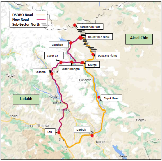
Map showing the old and new roads to DBO from Leh, Ladakh.
The new road has reached its most challenging phase, which involve navigating through steep terrain and building a 345-meter bridge with seven piers across the treacherous Shyok River. Popularly called the “River of Death,” the Syok’s aggressive currents are known to cause heavy floods during summers and monsoons, obstructing the construction process. There’s a reason the new road has been classified under the category of Hardness Index-III by the BRO.
To address these difficulties in the final phase, the construction uses state-of-the-art technologies. For instance, the ongoing construction of the 52-km-long stretch between Sasoma and Saser La involves using geocells to make the road resistant to weather and increase its bearing capacity. This stretch will be ready by November. Other key phases, such as the blacktopping of the 27-km stretch between Saser La and Saser Brangsa, will be completed by October 2024 and the 11 km of remaining work on the Saser Brangsa-Gapshan stretch will be ready within a year. Similarly, the 10-km route between Gapshan and DBO will be ready for use next year.
The aggression inflicted by China’s People’s Liberation Army (PLA) in 2020 led to a standoff between the PLA and the Indian Army in Galwan, increasing the urgency in constructing this alternate road, which starts from Sasoma. Reports claiming China is continuously working to develop infrastructure opposite eastern Ladakh and the south bank of Pangong Tso further expedited the project.
The much-ignored soda plains of eastern Ladakh have witnessed an undercurrent of infrastructure connectivity projects in the past few years owing to the muscle flexing by China. Realizing the significance of border connectivity, the Indian government has adopted measures to augment modernization and infrastructure development. That includes increased budgetary allocation for BRO, which was allocated 50 billion Indian rupees in fiscal year 2023-24, an increase of 43 percent from the previous year. Other reforms to speed up progress include enhancing the administrative and financial powers of BRO executives, systematic modernization of construction techniques, and relaxing certain restrictions related to environmental concerns.
As a result, the last three years have witnessed substantial development in India’s border road infrastructure, with 60 percent of the total roads built bordering China. Although the two sides have engaged in several dialogues, a comprehensive solution to the tension remains elusive.