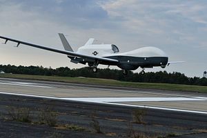
U.S. Navy officials confirmed that two MQ-4C Triton high-altitude surveillance Unmanned Ariel Vehicles will begin operating out of Guam by the end of this year. The Triton is a maritime-configured version of Northrop Grumman’s Global Hawk UAV built for the U.S. Air Force.
The Triton’s full set of capabilities, including future signals intelligence collection, will not be ready until 2021. The two systems deployed to Guam will have a preliminary set of maritime intelligence, surveillance, and reconnaissance (ISR) capabilities.
According to Northrup Grumman, the Triton’s manufacturer, the UAV can fly for more than 24 hours straight at altitudes over 10 miles and has an operational range of 8,200 miles. That flight radius would allow it to reach the coasts of North Korea, Taiwan, China’s Hainan Island, or the Spratly Islands and still have two to three thousand miles of range to loiter in the area before having to return to Guam.
The Triton will track surface ships with a combination of electro-optical sensors and radar and relay its information to facilities in the United States or to P-8 anti-submarine aircraft operating in the area.
A Northrop senior manager told C4ISRNET that Triton’s eventual intelligence capabilities, called “multi-INT,” are intended to take the place of the aging EP-3 aircraft. EP-3s have been repeatedly subject to unsafe harassment and intercept by Russian and Chinese military jets over the years. Famously, an EP-3 was forced to make an emergency landing at a Chinese military base on Hainan Island in 2001 after it a Chinese jet harassing it collided with the larger surveillance plane. The Chinese pilot was killed.
One advantage of unmanned systems is they are able to conduct sensitive missions without risking an aircrew. Conversely, this may embolden powers like Russia or China to conduct even more intense harassment of surveillance platforms, or possibly even interdict them. An incident is far less likely to result in dangerous conflict escalation over the loss of an unmanned platform compared to one that resulted in injured or dead aircrew.
Improved and persistent ISR is critical for the U.S. Navy to execute its strategies in the Pacific. Concepts like Distributed Lethality try to complicate an adversary’s targeting by dispersing platforms across a wide area, rather than concentrating them all in a strike group centered around an aircraft carrier, for example. But even though naval forces won’t be geographically concentrated, they would be able to concentrate their weapons by leveraging networked sensors. In a conflict, platforms like the Triton, which Northrup Grumman says can monitor a million square miles of ocean in a single surveillance flight, can be used to locate adversary fleets and then cue the U.S. Navy’s distributed assets to intercept them.
Even in peacetime, the Triton will be a critical asset for U.S. commanders in the Pacific, who have to monitor a huge geographic area. Admiral Harry Harris, the outgoing head of U.S. Pacific Command, told the House Armed Services Committee in February that the challenge of gathering intelligence in the Pacific region cannot be overstated, and that the mission required persistent, intrusive ISR to provide indications and warning of threats and situational awareness. As a commander, he needed credible ISR to provide to treaty allies who lacked the United States’ resources, to prevent strategic surprise by potential adversaries, and create “decision space” for national leadership to have the time and information necessary to choose a course of action that could mean the difference between war and peace, or escalation or de-escalation.


