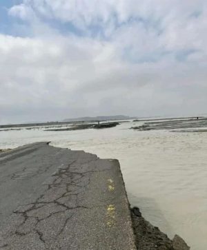
While world leaders gathered at COP29 in Baku, Azerbaijan, last week to discuss some of the world’s pressing climate change vulnerabilities, far from the spotlight, Pakistan’s southwestern port city of Gwadar hosted its own climate resilience and awareness sessions to confront its existential challenges.
Over the past three years, local conferences and community discussions have increasingly drawn attention to how this peninsula, which is surrounded by the Arabian Sea on three sides, is grappling with rising sea levels, groundwater intrusion, recurrent urban flooding, as well as its precarious position atop the Makran Subduction Zone.
Gwadar’s geography is both its strength and its greatest vulnerability.
Its location has historically positioned it as an important natural port within the Indian Ocean’s maritime trade network, and more recently, a critical node in the China-Pakistan Economic Corridor (CPEC). In the past two decades, its strategic location has attracted significant Chinese investment in Pakistan. Yet, the same location that makes Gwadar a valuable economic asset also leaves it highly susceptible to the cascading impacts of climate change and natural disasters.
Being a low-lying coastal area, Gwadar is particularly vulnerable to rising sea levels. However, some natural and man-made structures offer partial protection.
To the south, the town is shielded by Koh-e-Bateel, a headland, rising 150 meters and stretching 7 miles from east to west. On the eastern side, the newly constructed, six-lane East Expressway serves as a barrier, while both the Expressway and the western Marine Drive road are fortified with large boulders serving as a seawall to guard against waves and erosion.
Yet, despite these measures, seawalls against the roads on both sides of the city present challenges.
Research in India on similar seawalls found that while seawalls effectively shield infrastructure from storm surges and wave-induced erosion, they often disrupt natural coastal processes, leading to accelerated erosion on adjacent beaches. This has been evident in the nearby fishing villages of Sur Banden and Ganz in Gwadar, which have faced significant erosion in recent years.
Second, rising groundwater is another serious but often overlooked threat in Gwadar. Rising groundwater and seawater intrusion erodes infrastructure and roads from beneath and causes seawalls to trap water seeping up from the ground, leading to more flooding. It can also crack home foundations, causing sewers to backflow and damage local plants and vegetation, resulting in infertile land.
Research by Pazeer Ahmad, a local hydro-geologist, and his colleagues found that the central part of Gwadar, being at lower elevation, is particularly vulnerable to saltwater intrusion as sea levels rise. This research underscores the alarming rate at which saltwater is encroaching, increasing groundwater levels and making the city’s infrastructure, especially in the central areas and its historic old town, prone to collapse.
Third, the threat of natural disasters in Gwadar extends beyond rising sea levels and groundwater intrusion. The city is situated atop the Makran Subduction Zone (MSZ), a tectonic boundary where the Arabian Plate is sliding beneath the Eurasian Plate. This geological feature is responsible for earthquakes and volcanic activities along the Strait of Hormuz from Iran to Pakistan’s Karachi. However, studies on the region emphasize the contrasting seismicity between the eastern and western parts of the plate, where the eastern segment has remained more active and witnessed large thrusts of earthquakes.
These studies also identified seven large earthquakes along this zone over the past 500 years, with none surpassing the magnitude of the 1945 earthquake, which remains etched in the memories of Gwadar’s elderly residents. Furthermore, these studies have also suggested that similar earthquakes might occur roughly in 175 years in the MSZ. This ongoing seismic risk underlines the need for resilient infrastructure in the region.
In addition to these geophysical and environmental challenges, Gwadar’s climate vulnerability has been further exacerbated by shifting weather patterns linked to global climate change. While the city has long been characterized by its dry, arid climate, recent years have witnessed more unpredictable and extreme weather events.
In 2022, torrential rainfall submerged large parts of the city, damaging infrastructure and displacing residents. The cycle repeated in 2023, followed by a record 30-hour heavy downpour in early 2024. These extreme weather events signal a shift in the region’s climate dynamics, increasing the risk of urban flooding and further stressing Gwadar’s already fragile infrastructure, especially in the old town.
Addressing these complex issues requires a nuanced understanding of local contexts, policy frameworks, and technological advancement. Integrating local knowledge, as well as empirical studies, are vital for informed decision-making, as is political will and commitment to ensure the voices of affected communities are included in the discussion and their concerns are taken seriously. Collaborative efforts between local organizations and national policymakers can help with climate resilience strategies.
While local researchers and community organizations such as the Rural Community Development Council (RCDC) are taking steps, including establishing a “Climate Resilience Information Center,” to engage with awareness and dialogue, these efforts need support at the provincial and national levels.
Pakistan’s Climate Change Action Plan (2021-2025), National Climate Change Policy (2014- 2030), and National Adaptation Plan (2023) provide frameworks for addressing coastal vulnerabilities and building resilience. Yet implementation and further research into an important port city like Gwadar’s unique challenges remain hindered by ongoing economic and political crises. Meanwhile, residents in Gwadar and other vulnerable regions await the translation of existing plans and strategies into tangible actions to mitigate escalating climate risks.


